These roads have not always had the same layout, nor the same landmarks. In fact, they have been articulated on the two old meat trails that crossed very close to the old hermitage and that communicated these production areas with the most significant urban centers of this area during the Ancien Régime: Moguer-Sevilla and Niebla-Sanlúcar de Barrameda.
The Rocío Roads are those land routes that cross the provinces of Huelva, Seville and Cadiz partially through the natural area of Doñana. These roads have not always had the same layout, nor the same landmarks. In fact, they have been articulated on the two old meat trails that crossed very close to the old hermitage and that communicated these production areas with the most significant urban centers of this area during the Ancien Régime: Moguer-Sevilla and Niebla-Sanlúcar de Barrameda; trails that gained greater significance as a result of the discovery of America. Later, the explosion of the Rocío at the beginning of the decade of the 80s of the twentieth century and the arrival of the media, modified some routes and substantially the notoriety of some milestones of the road that never had it before.
It should be noted that there are currently five main routes to reach the village of El Rocío: The path of the brotherhoods of Seville that has its point of arrival in the village by the bridge of the Ajolí. The path of the brotherhoods of Cadiz, which has its point of entry in the village, through Manecorro– the Canaliega; the path of the brotherhoods of Huelva, with access through the neighborhood of “The chickens”– the Tinajas; and the roads of the Plains and of the Tarajaleso “Tananjales”, the last one to be recovered, which runs parallel to that of Los Llanos. The brotherhoods and associations of El Rocío make their annual pilgrimage through them.
Roads to El Rocío-Source Ana Ramírez Torres
arrival from the northeast
Road of the Seville Brotherhoods
Palace and Raya Real
Ajolí Bridge
This transit, which ends at the historic Ajolí Bridge , reaches the village from the northeast, crossing the old Cazadero Real del Lomo del Grullo, now called Coto del Rey (King’s preserve) and National Park. This itinerary with its many variants is the most publicized and most traveled, since it is used by sixty percent of the brotherhoods that make the pilgrimage from various parts of the province of Seville, including those from Huelva that come from the end of the province, closer to that province. These brotherhoods usually spend one or two nights in Doñana, with almost all of their landmarks under their influence: Hato Blanco, Gato, Cerro Tía Cana, Cancela del Urracal, Pozo Máquina, Raya Real, Palacio del Rey, Cañada Mayor, El Vicioso, El Pinto, Matasgordas.
There are different derivations in the roads of Seville, depending on the geographic point of departure in the province of Seville, such as the so-called “San Diego Road”.which connects Coria, where several brotherhoods cross the Guadalquivir River, with the Vado del Quema, or the “Camino de Lebrija”. that, through Isla Mayorflows into the Ajolí bridge.
The truth is that after crossing several towns in the province, where acts of brotherhood and courtesy are repeated, the most significant geographical landmarks of this road are the crossing of the Guadiamar, in the so-called “vado del Quema”, which is named after a farmhouse located nearby in the municipality of Aznalcazar. The place is a must for a large number of brotherhoods of El Rocío, who live this moment in an atmosphere of joy and devotion, which offers beautiful pictures of the pilgrimage. And the arrival and crossing of the Ajolí stream, a symbolic place that marks the end of the road and the arrival at the village of El Rocío.
Moguer Road
Road of the Huelva Brotherhoods
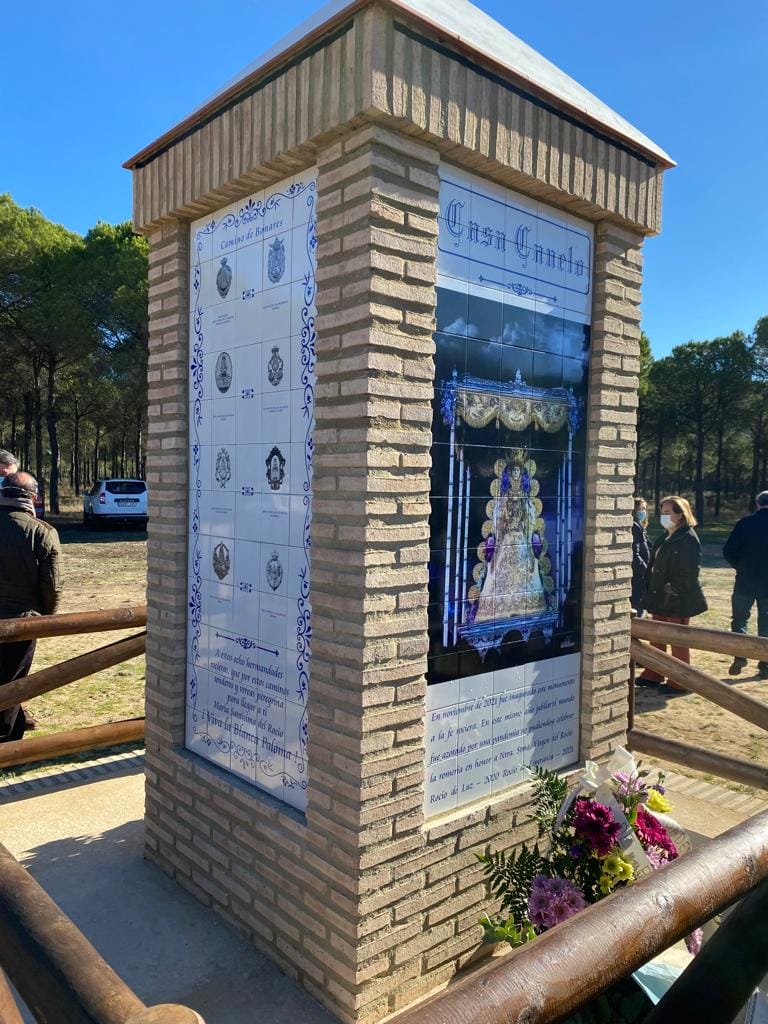
A significant number of the brotherhoods of Huelva, located in the western part of the province, follow this route. It is also known as “Camino de Moguer” which leads to El Rocío through “the neighborhood of the hens”, after passingthrough the Doñana Natural Park, the Protected Area of La Rocina and an important sector of the so-called Places of Community Interest. Some of the most relevant milestones of this road are: El Milanillo, Tres Rayas (where the brotherhood of Huelva spends the night, as their walk lasts two days), Ermita de Montemayor, la Rocina, Abalario, Corchito, Pino Galés, Bodegones, Cabezudos, Pino Gordo, Casa del Canelo, Las Macetas, Villarejo, arroyo de la Cañá, caño de la Venta or las Tinajas.
Depending on their geographical location, the different brotherhoods go through different variants.
There is an important derivative for the roads of Huelva which is the road to Bonares, which takes advantage of the old road that linked Almonte with this town in the western Condado and that the brotherhoods located in this area and in the flat land of Huelva, closer. Those who have recently blessed a monolith in the so-called “Casa del Canelo”, in the municipality of Almonte. These brotherhoods make a shorter route and only have one night of overnight stay, and make their arrival at El Rocío, through the road of Los Llanos.
We also find another derivative on the road to Hinojos, which is made by several brotherhoods and which joins this municipality with the village of El Rocío, making its entrance in El Rocío, by the Ajolí Bridge.
Through the Heart of Doñana
Road of the Cadiz Brotherhoods
To the Manecorro-La Canaliegacrossing the heart of the National Park through the old stately meadows of Doñana, the brotherhoods of Cadiz and Ceuta arrive, in a much smaller number, from Sanlucar de Barrameda, where they cross the Guadalquivir River. As in the previous ones, three days and two nights are usually spent in crossing these sands and some of the most outstanding signs of identity are: Malandar, Marismillas, Cerro del Trigo, Las Nuevas, Las Pajareras, Corral de Felix, El Sopetón,Guaperal,…
On this road the disconnection with the urban world is greater, since from Bajo de Guía to La Canaliega there is no contact with asphalt, nor with any population center.
Doñana's protected areas
Llanos and Los Tarajales o “Tananjales” Road
The Camino del Condado Oriental and Almonte ends at the old Camino de Los Llanos, linked to the Protected Areas of Doñana with the recent approval of the SCIs, although the routes of its brotherhoods cross forestry and/or agricultural areas of great interest to local-regional societies. Through this road enter the Brotherhood of Almonte and those of the nearest towns(Bollullos, La Palma…) as well as some others that come from further away and cannot make it from there, such as Madrid or Badajoz.
In 2016, some of the most serious problems of the old road of Los Tarajales or Tananjales, which runs parallel to the previous one, and to which a significant number of the last filial brotherhoods that come from further away have been derived, have been solved.
The historical cartography reflects the road connections of Almonte with the village of El Rocío, differentiating the route of the Camino de Los Llanos from the Camino de Tarajales.
"All the flowers were born
of the garden of the universe".